Updated Surplus Numbers

Updated Surplus Numbers
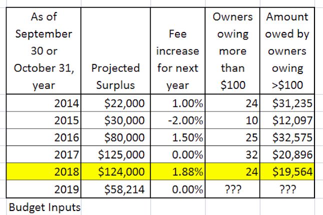
Updated Surplus Numbers: Actual surplus 2018 per audit was $85,163.
Boards 2011-2018 implemented policies and procedures with specific goals:
stabilize owner fees, achieve maintenance objectives and achieve annual budget surpluses.
Any surplus was retained by the association.
The board elected in fall 2018 decided to increase owner fees, even in view of a large potential surplus

Average fees prior to 2019

Average fees prior to 2019
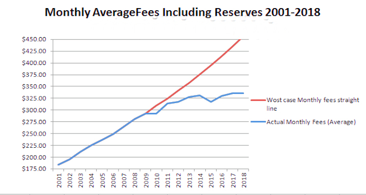
Average fees per owner prior to 2019:
RED indicates the consequences had boards continued the fee policies prior to 2010,
BLUE indicates actual fees. These moderated when better policies and financial controls were put in place by boards

Better budgeting could have resulted in lower fees

Better budgeting could have resulted in lower fees
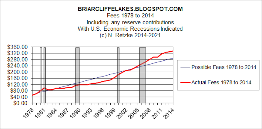
Better budgeting could have resulted in lower fees:
RED line = actual fees enacted by boards,
BLUE line = alternate, fees, ultimately lower with same association income lower had
boards used better financial controls and focused on long term fee stability

Monday, June 22, 2015

Yet Another Thunderstorm is on the Way!

0 comments

Bookmark and Share


Update June 23, 2015 9:00am: The storm dissipated last night with little rain in the immediate area. Today it's blue skies and calm. Now I must get back to work. Yesterday I hiked the property before the storm and send one photo to management re: issue at Wheaton's Lake 3.

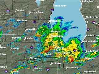
Update 3:55pm: The storm is moving eastward. Not too bad, so far, but there is a line of thunderstorms extending to Iowa and thunderstorms are expected tonight. Satellite image per NOAA:  at 1945Z (2:45 pm CDT)


Update 10:25am: The masthead photo is an infrared image. Looks ugly in the Midwest. See notes at the end of this post.

Yet another thunderstorm is on the way. Over at the NOAA/NWS there is a "Severe Thunderstorm Watch." There is also a "Hazardous Weather Outlook". Here are the texts:

Hazardous Weather Outlook

HAZARDOUS WEATHER OUTLOOK
NATIONAL WEATHER SERVICE CHICAGO/ROMEOVILLE IL
443 AM CDT MON JUN 22 2015

ILZ003>006-008-010>014-019>023-032-033-039-INZ001-002-010-011-019-
230945-
WINNEBAGO-BOONE-MCHENRY-LAKE ILLINOIS-OGLE-LEE-DE KALB-KANE-
DUPAGE-COOK-LA SALLE-KENDALL-GRUNDY-WILL-KANKAKEE-LIVINGSTON-
IROQUOIS-FORD-LAKE INDIANA-PORTER-NEWTON-JASPER-BENTON-
443 AM CDT MON JUN 22 2015

THIS HAZARDOUS WEATHER OUTLOOK IS FOR NORTH CENTRAL ILLINOIS...
NORTHEAST ILLINOIS AND NORTHWEST INDIANA.

.DAY ONE...TODAY AND TONIGHT.

  WEATHER HAZARDS EXPECTED:

  THUNDERSTORMS...THE STRONGEST MAY PRODUCE:
    DAMAGING WINDS IN EXCESS OF 70 MPH.
    HAIL TO THE SIZE OF GOLFBALLS.
    HEAVY RAIN.
    FREQUENT CLOUD TO GROUND LIGHTNING.
    PERHAPS A TORNADO OR TWO.

  AREAS AFFECTED AND TIMING:

  THERE IS A CHANCE OF THUNDERSTORMS WITH AN ASSOCIATED LOW RISK
  OF DAMAGING WINDS LATE THIS MORNING INTO EARLY THIS
  AFTERNOON...MAINLY NORTH OF INTERSTATES 88 AND 290. THE
  POTENTIALLY MORE SIGNIFICANT THUNDERSTORM AND SEVERE WEATHER
  THREAT LOOKS TO BE EARLY THIS EVENING...ESPECIALLY NORTH OF
  INTERSTATE 80. THUNDERSTORMS WILL SPREAD SOUTH OF I-80 MID TO
  LATE EVENING WITH THE SEVERE THREAT GRADUALLY DIMINISHING.

  DISCUSSION:

  ISOLATED THUNDERSTORMS ARE POSSIBLE THROUGH MID MORNING AHEAD
  OF A CLUSTER OF THUNDERSTORMS THAT WILL RACE RAPIDLY EASTWARD
  ACROSS SOUTHERN WISCONSIN OR NORTHERN ILLINOIS LATE THIS
  MORNING OR EARLY THIS AFTERNOON. SOME LIMITED THREAT OF
  DAMAGING WINDS COULD ACCOMPANY THE STORMS LATE THIS MORNING
  INTO THIS AFTERNOON.

  EXPLOSIVE SEVERE THUNDERSTORM DEVELOPMENT IS EXPECTED ACROSS
  SOUTHERN WISCONSIN SOUTHWEST INTO IOWA LATE THIS AFTERNOON.
  THESE STORMS ARE THEN FORECAST TO SPREAD SOUTHEAST INTO
  NORTHERN ILLINOIS EARLY THIS EVENING. ASSUMING STORMS DEVELOP
  AS EXPECTED...THEY WOULD POSE A RISK OF LARGE AND DAMAGING HAIL
  AS WELL AS STRONG DAMAGING WINDS. AN ISOLATED TORNADO OR TWO
  CANNOT BE RULED OUT. IN ADDITION...THE STORMS WILL BE CAPABLE
  OF PRODUCING TORRENTIAL DOWNPOURS AND ISOLATED MINOR FLOODING
  PROBLEMS. THE THUNDERSTORMS WILL SPREAD SOUTHWARD AND AFFECT
  AREAS SOUTH OF INTERSTATE 80 BY MID TO LATE EVENING...THOUGH
  THE THREAT OF SEVERE WEATHER IS EXPECTED TO GRADUALLY DIMINISH
  AS THE EVENING WEARS ON.

MODERATE TO MAJOR FLOODING CONTINUES ON THE PORTIONS OF THE IROQUOIS
RIVER...MODERATE FLOODING CONTINUES ON THE ILLINOIS RIVER NEAR LA
SALLE...AND MINOR TO MODERATE FLOODING CONTINUES ON PORTIONS OF
THE KANKAKEE RIVER.

.DAYS TWO THROUGH SEVEN...TUESDAY THROUGH SUNDAY.

THUNDERSTORMS ARE POSSIBLE AGAIN AS EARLY AS WEDNESDAY...BUT ARE
MORE LIKELY WEDNESDAY NIGHT INTO THURSDAY MORNING. SOME OF THESE
STORMS COULD POTENTIALLY BE SEVERE...THOUGH THE MORE LIKELY HAZARD
WILL PROBABLY BE HEAVY RAINFALL AND THE THREAT OF FLASH FLOODING.

PORTIONS OF THE IROQUOIS...KANKAKEE...AND ILLINOIS RIVERS WILL
REMAIN IN FLOOD.

.SPOTTER INFORMATION STATEMENT...

SPOTTERS MAY BE NEEDED...ESPECIALLY EARLY THIS EVENING.

&&

$$


Severe Thunderstorm Watch

SEVERE THUNDERSTORM WATCH OUTLINE UPDATE FOR WS 332
NWS STORM PREDICTION CENTER NORMAN OK
935 AM CDT MON JUN 22 2015

SEVERE THUNDERSTORM WATCH 332 IS IN EFFECT UNTIL 300 PM CDT
FOR THE FOLLOWING LOCATIONS

ILC007-011-031-037-043-053-063-073-075-089-091-093-097-099-103-
105-111-123-141-155-161-175-195-197-201-222000-
/O.NEW.KWNS.SV.A.0332.150622T1435Z-150622T2000Z/

IL
.    ILLINOIS COUNTIES INCLUDED ARE

BOONE                BUREAU              COOK
DE KALB              DUPAGE              FORD
GRUNDY               HENRY               IROQUOIS
KANE                 KANKAKEE            KENDALL
LAKE                 LA SALLE            LEE
LIVINGSTON           MARSHALL            MCHENRY
OGLE                 PUTNAM              ROCK ISLAND
STARK                WHITESIDE           WILL
WINNEBAGO
$$

Notes:
NOAA/NWS infrared image and official comments:


"Meteorologists use color enhanced imagery as an aid in satellite interpretation. The colors enable them to easily and quickly see features which are of special interest. Usually they look for high clouds or areas with a large amount of water vapor.

In an infrared (IR) image cold clouds are high clouds, so the colors typically highlight the colder regions. The bar on the right side of the image indicates the pixel brightness values for the corresponding color. The intensity value represents emitted infrared radiation. The intensity of a pixel is recorded as a digital number (for example, in these images the numbers range from 0 to 255.) You can determine temperatures using one of the formulas below:

If B > 176, T = 418 - B; or
if B <= 176, T = 330 - (B/2)

Note that the resulting temperatures are in Kelvin.

To calculate the resulting Kelvin temperature to Fahrenheit: (K - 273.15) x 1.8 + 32.00.

To calculate the resulting Kelvin temperature to Celsius: C = K - 273.

(B = Brightness value; T = Temperature; F = Fahrenheit; C = Celsius)"

Here is the original link over at NOAA:

Click for current Eastern US Infrared Image



Sunday, June 21, 2015

Glen Ellyn "luxe" Hotel and "Fine Dining" Restaurant Makes Midwest Living List of Weekend Getaways

0 comments

Bookmark and Share


The Patch recently posted an article about Glen Ellyn; there is a link at the conclusion of this post. In fact, it is ironic, because the article is really about the money losing hotel and restaurant at the (community) College of DuPage. These are supported via the taxpayer and transfers from other college funds.

While Glen Ellyn's downtown area atrophies (the McChesney & Miller grocery and market closed, the pharmacy closed, as have the Geische's which was another long time anchor). So too for numerous shuttered clothing stores. Restaurants come and go, as do the small shops. Yet,  according to Midwest Magazine, 3.6 miles from GE's downtown lies the main attraction and reason to come to  Glen Ellyn. These are the "luxe" hotel and "fine dining" restaurant at the College of DuPage. In fact, one can simply hop on I-88 to get there and bypass the village, travelling through GE's unincorporated areas to get to the college.

I say this is ironic, as these compete with lots of nearby private establishments and are merely college amenities in a 'community' college. IMHO these are, in fact, white elephant artifices built with $tens of millions of loans (bonds). The homeowners in Glen Ellyn are on the hook to pay these bonds via their taxes. In fact, the property taxes on a median value home in Glen Ellyn are about $11,000 annually. Of course, other communities in DuPage and Cook counties are also on the hook, if they are within School District 502. Furthermore, the "community" College of DuPage has run these establishments at very large losses. Apparently these "laboratories" as President Robert Breuder once described them to nearby residents, can and should lose money while drawing visitors and residents away from nearby private establishments. So the nearly $500,000 in losses last year were made up from tax revenue and by diverting funds from other college funds via President and Board dinners and lunches (over $200,000 for these, apparently,)

However, the college, thanks to its "unlimited" taxing ability, can run these establishments to compete with non - tax subsidised private businesses in downtown Glen Ellyn, and even the struggling restaurant Reserve 22 at the adjacent Village Links (of Glen Ellyn) Golf Course.

While this betrayal of public trust may not be a crime, it certainly seems that the old adage "crime does pay" seems very, very true. These tax sucking, special perk amenities have been lauded in Wine Spectator magazine and now in Midwest Living magazine. But I suppose the aristocratic class enjoys these amenities, as did Robert Breuder and the board under which these white elephants were built. The sad thing is, long after Breuder and the gang of trustees who did this are long gone, taxpayers will be footing the bill. Not for a few years, mind you, but for decades! IMHO, simply another reason to leave Illinois.

Here is a summary of the Patch article dated June 18, 2015. 

"Glen Ellyn Makes Midwest Living List of Weekend Getaways Near Chicago

Glen Ellyn made Midwest Living's list of the top 25 best weekend getaway near Chicago."


"Midwest Living magazine has listed Glen Ellyn among its top 25 weekend getaways near Chicago. The College of DuPage received credit by Midwest Living for propelling Glen Ellyn onto the list." The article then quoted the magazine article. However, the quote downplayed the magazine's description of the hotel.

In fact, the Midwest Magazine article stated “At the College of DuPage in Glen Ellyn, Illinois, white-tablecloth dining and luxe hotel make for exciting school nights. A professional executive chef turns out intricately crafted dishes at Waterleaf, a fine-dining restaurant at the college. After dinner, check into a room on the third floor of the same building on campus to enjoy plush beds, oversize showers and trays of chocolate truffles. Activities on and off the campus round out a weekend.”

Click to enlarge:

Click to open Patch article dated June 18, 2015

Saturday, June 20, 2015

Wheaton Seeks Applicants for Stormwater Project Engineer Position

1 comments


Bookmark and Share


From Wheaton's Weekly June 17, 2015:

City Seeks Applicants for Stormwater Project Engineer Position 
The City seeks applicants for a Project Engineer position to perform civil engineering tasks related to local stormwater studies, analysis of drainage concerns, data collection and organization on major storm events, and stormwater capital projects.

Here's a link to their website with the details. Clink to open a new web page:

Wheaton Jobs - Project Engineer - Stormwater


Thursday, June 18, 2015

Additional Rain Activity - Tropical Storm Bill

0 comments


Bookmark and Share


We're getting a real cloudburst here from a fast moving thunderstorm. However, this storm will be out of the area in about an hour. Should not cause a problem on Wheaton's Lakes or COD's ponds in Glen Ellyn.

7:40am Radar from NOAA.gov:


Tropical storm Bill is sending rain into the area. For the immediate future that rain will be elsewhere. According to the NOAA "Tropical moisture from Bill will continue to bring heavy rain to the southern Plains, mid-Mississippi River Valley and Ohio Valley through Thursday. Numerous Flash Flood Watches are in effect across these areas. River flooding is also likely in these areas as the heavy rainfall drains into areas rivers."  Here's the current wide area radar (reflectivity) data from the NOAA:


Wednesday, June 17, 2015

Lake 4 Discharge (Outflow) Condition

0 comments


Bookmark and Share


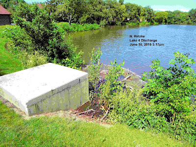
Here's a photo taken at 2:25pm today. The Superintendent of Sewers for the city emailed me and stated that the "outfall" is flowing "at design capacity" and that, I presume, means it is normal. Here is how the outfall looked from within the storm sewer concrete container after the city had inspected it:


Here is the way it looked yesterday: 


Seem to be about the same; my viewing angle was different. You should try taking these photos. Some floating debris was cleared this afternoon. However, it was floating above the entry point and could not have interfered with the "outfall." It would seem the flow was at maximum yesterday. 

It would also seem that conditions (rainfall, ground moisture content, etc.) were about all that the lake system can currently handle. I include College of DuPage's ponds on their southwest boundary and Wheaton's Lakes A, 1, 2, 3 and 4. 

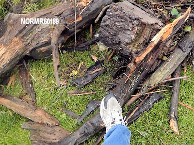
Here's the debris, with my shoe to provide some perspective:


Current Conditions - Wheaton Lakes 2, 3 and 4

0 comments

Bookmark and Share


Update: According to the City of Wheaton at 3:04 pm, the outflow of Lake 4 "is flowing at design capacity."

Original Post: Prior to beginning my work day I went to Wheaton's Lakes 2, 3 and 4. Lake 2 feeds Lake 3, and Lake 3 feeds Lake 4. Water flows downhill from further north in this very large watershed which is 1/3rd in Glen Ellyn and 2/3rd in Wheaton. This post includes several photos and a brief video.

I received an "out of office" response to my email yesterday. That automated response was from Wheaton's Director of Engineering. I have not yet received a response from the Mayor, City Manager, Assistant City Manager, Public Works, or Councilmen.  I expressed a concern about the levels of the lakes and also that the flow control device at the discharge of Lake 4 may not be completely open. This "gate"is managed and locked by the City of Wheaton.

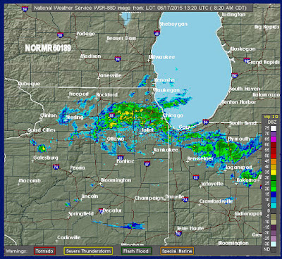
It is currently raining. Here is the NOAA.gov radar image at 8:20am this morning:


The levels of Lakes 2, 3 and 4 have fallen over the night, which was dry (no rainfall).

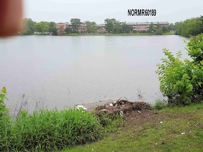
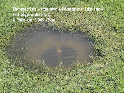
Here is the situation at the discharge of Lake 3 at about 8:15am this morning. The level of the storm sewer connecting Lakes 3 and 4 had fallen about a foot. The Levels of both Lakes 3 and 4 have decreased. However, the level of Lake 3 is completely above the storm sewers which empty into this lake, and bring water from further north. Of course, as water flows from upstream both Lakes 3 and 4 will continue to fill, and the restrictor placed upon the discharge of Lake 4 by the City of Wheaton reduces the volume of discharge. The City of Wheaton has an easement upon these lakes and controls the levels, directly via the storm sewers from the upstream lakes, the restrictor placed upon the discharge of Lake 4 by the City and the position of the Lake 4 discharge gate.

The very top of the discharge storm sewer at Lake 3 is exposed, but the inlets at the other side of the lake remain under water:


The level of the water at the storm sewer grate which is at the discharge of Lake 3 is now exposed. The lake level has dropped about one foot since 4:00pm yesterday:


The level of Lake 4 has also dropped and there is a continuous flow of water through the discharge. However, the condition and position of the discharge gate is unknown to me.


Tuesday, June 16, 2015

Wheaton Lake 4 Level Very High

0 comments

Bookmark and Share


The water levels in Wheaton's Lakes 3 and 4 are very high.

As of 4:00pm today Wheaton's Lake 3 level was very high, above the level of the entry storm sewers and also above the entry of the city's 42 inch storm sewer discharge and entry points which connect Wheaton's Lakes 3 and 4.

I am sending information to the city because I have a concern that the discharge of Lake 4 is restricted. There is a "gate" which the city controls and padlocks. I include several photos of the discharge of Lake 4 and I suspect the gate is not fully open. Meanwhile, the lake continues to fill from Wheaton's lakes upstream, as well as portions of the watershed in Glen Ellyn and the College of DuPage.

As of 3:20pm today, the levels of Lake 3, Lake 4, the Hoddinott pond and College of DuPage's pond 9 were all at the same level. Meanwhile water continues to flow from Wheaton's upstream Lake 2.

The City of Wheaton extercises control over these lakes, and the Village of Glen Ellyn's College of DuPage also directs stormwater from their campus to Lake 4 via a series of underground storm sewers and their Hoddinott pond, which is connected to Wheaton's Lake 4 by a weir. As of today, that weir is completely under water, and so the Hoddinott pond and Lake 4 at at identical levels.

Here is the situation at the discharge of Lake 4 as of 3:30pm today. Wheaton controls the lock which opens a flow control device at the discharge of Lake 4. I am concerned this flow control device is not fully open.

Wheaton's Lake 4 discharge point:

Wheaton's lock which controls the discharge of Lake 4

Interior of Lake 4 discharge:


To substantiate my statement that the levels of the lakes are identical (or nearly so), here is a photo of the first storm sewer entry point after Lake 3. This storm sewer interconnects Lakes 3 and 4. 

I have made videos of some of the conditions and I'll be posting these. 


Monday, June 15, 2015

Rain, Rain Go Away - Ducks and Mosquito Glade, Revisited

0 comments

Bookmark and Share


The photos in the previous post show an area that was more water prone 5 years ago. One board replaced a portion of the walk, but one of the tasks I took upon my self was to have the area thinned. It was overgrown with trees, which had intertwined and created a small glade of perpetual dusk. Rainwater would stand, or the area would remain damp for days after heavy rainfalls. There was simply insufficient sunlight striking the ground to grow grass or dry the area out.

There is a plan to improve the drainage in this location, but there are so many tasks. With the removal of a large (dead) ash to the south last year, improving the drainage may be a real possibility. However, there are about 50 other areas which also require remedial work, after the removal of ash trees, or new roofs and drainage.

Here is the "before" video, taken in August 2010.


Here's another view of the area, this video from May, 2010:


Rain, Rain, Go Away?

0 comments

Bookmark and Share


Update 4:35pm
We continue with intermittent rain and that is the prediction for the entire week. Now, this might seem to be a lot of rain, but NOAA.gov provides the following for this storm. These are the storm totals and current conditions. For my immediate area, the total rainfall for this storm is about 2 inches, with more to come. At this rate, we won't get to 1% (100 year) conditions; the NOAA is predicting an additional 1/4 inch late this afternoon and tonight. However, there are flash flood warnings. I provide this to document this storm, which is not an unusual one for this area. It will produce standing water and some inconvenience:


Here's the current radar:

Original Post:
We've had a rash of rain storms move through the area in recent days. Today is another thunderstorm with locally heavy rain, This is the NOAA radar current image:


Meanwhile the rain settled in some low areas and the ducks were really enjoying Sunday's storm:

The puddle above quickly drained into the soil, but today's new storm created another puddle.  As the rain saturates the soil, the time to drain will become longer. We know this, and the area in the photo is on the list of problems and issues to deal with. However, as this area drains in a few hours, it isn't considered an "emergency" by me. Of course, a very few owners who are annoyed by paying their monthly fees have a different opinion.


Friday, June 12, 2015

Hanging Gardens of BLMH

0 comments

Bookmark and Share


We have hanging gardens in our HOA. Many residents have planters on their patios and decks, However, nature too comes to our aid.

This is one of the years that the maple trees drop an abundance of seeds. These "helicopters" can be seen spinning throughout the day in the spring. This does happen every year, However, about every other or every third year the trees simply go wild and there are seeds everywhere, many in the gutters of the buildings. I can't say why this is, Perhaps the trees rest for a year or so.

This year was an abundant year. Maintenance has been intermittently cleaning gutters for several weeks. In fact, it doesn't make sense to do this while the seeds are falling, because whatever is scooped out is quickly replenished by a new supply.

How many gutters do we have? By my guess, about 2 miles of gutters. Yes, you did read that correctly. Our little HOA has two miles of gutters. These have been filled with many tens of thousands of seeds.

We're reaching a finale here, and the maples have exhausted most of their seedlings. However, with the plentiful rain, those seeds are attempting to become trees.  They add to the hanging gardens in our HOA. Not to be outdone, the pines have been dropping cones. In fact one owner complained because these were littering the ground. Yep, living in a forest can be a real burden. Ha, ha! Now, are we really a forest? No. This HOA has about 15 acres of landscaped turf and perhaps 700 tress. It's a manicured environment. No wonder some of the residents complain when there are pine cones littering the property! Why, how inconsiderate of nature.


Wednesday, June 10, 2015

Water Main Finale

0 comments

Bookmark and Share


The water mains were completed, and the one length that needed to be "sanitized" passed the city inspectors.

Isn't it wonderful when the residents pay for all of this infrastructure while the city of Wheaton collects the taxes and fees for permits? You betcha!  Here's a trick question. Do you think the city requires its water or maintenance department to take out a permit and pay a fee each and every time a fire hydrant is replaced? Yet they do in a HOA. Yep, it's all about collecting fees. The city is feeling the pinch as the State of Illinois, aka State of Disaster, aka State of Madigan goes through the throes of its financial death.

I'll probably run a slide show at the HOA meeting tomorrow, so most of the board which was elsewhere for most of this project is kept fully informed.

That's not a criticism. It's a statement of reality. We all have other things to do, and for about 97% of the owners, it is about avoiding HOA meetings, and for about 10% of the HOA owners, it is about avoiding paying their HOA fees.

Isn't life wonderful?