Updated Surplus Numbers

Updated Surplus Numbers
Updated Surplus Numbers: Actual surplus 2018 per audit was $85,163.
Boards 2011-2018 implemented policies and procedures with specific goals:
stabilize owner fees, achieve maintenance objectives and achieve annual budget surpluses.
Any surplus was retained by the association.
The board elected in fall 2018 decided to increase owner fees, even in view of a large potential surplus

Average fees prior to 2019

Average fees prior to 2019
Average fees per owner prior to 2019:
RED indicates the consequences had boards continued the fee policies prior to 2010,
BLUE indicates actual fees. These moderated when better policies and financial controls were put in place by boards

Better budgeting could have resulted in lower fees

Better budgeting could have resulted in lower fees
Better budgeting could have resulted in lower fees:
RED line = actual fees enacted by boards,
BLUE line = alternate, fees, ultimately lower with same association income lower had
boards used better financial controls and focused on long term fee stability

Monday, June 25, 2012

The Issues of COD Expansion - Part III - Runoff, Wetlands and Flood Concerns

4 comments
Originally posted June 25, 2012. Note 4 revised thereafter.

Runoff, Wetlands and "Zone A" Flood Hazard Areas
BLMH is high and dry, but is bounded by "Zone A" Special Hazard Areas to the north and south. These areas will be "inundated by the 1% annual chance flood events." In other words, the water levels of Lakes 3, 4 and the wetlands on COD property will rise during a "100 year" flood. As the levels rise, the water flow from Lake 3 to Lake 4, and from the wetlands to Lake 4, will increase. There is a large underground connection between Lake 3 to Lake 4. However, the flow of storm water into Lake #4 is greater because of the connection from the wetland to the east. That wetland, in turn, receives runoff from the College of DuPage.

This post will be shorter than the previous one.(Note 4). I'll provide sufficient photos to stitch together the story and provide the locations and relationships of some of the structures described.

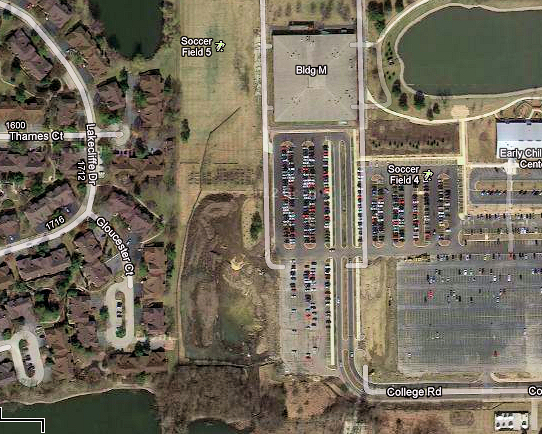
Here's an overall view of the western extreme of the campus and of most of BLMH, as it existed in the spring of 2012. The view faces North by Northeast and provides an indication of how the special "Zone A" areas and the COD campus "boxes in" the association. Lake #3 is to the North, the college is to the east, Lake #4 is to the South, and the "wetlands" are to the Southeast. This also shows the recent "material staging" and "pond 9" college construction, both of which are incomplete. This post will focus on the southwest area of the campus:

Click on Photos or Graphics to Enlarge Them!


The wetland of concern is in the southwest corner of the campus. That wetland drains into Lake #4. This post will detail how this drainage system is interconnected.

Problems in the wetlands can result in flooding at the church south of the campus and west of Lambert. Since that church is adjacent to the satellite antenna farm of the college, it must be in the area the college recently referred to as the "Service Area" of the campus! Here's the Church, the satellite farm and the Radio Tower of the campus, south of "Parking 6." This is due east of the wetlands, the beginning of which is visible surrounding the radio tower:

Consequences of High Water Levels
High levels in Lake #3 or 4 can result in shoreline damage and an increase in the fees that our owners pay to maintain these shorelines and to deal with the consequences of problems on the lakes. In other words, if the college doesn't get it right, under the current system our owners will pay to clean up the damage.

The lakes and the "wetlands" on COD property are part of a complex, interconnected system to control rainwater and avoid flooding in this part of the County. It does this by providing some "retention" of rainwater and by also providing controlled flow to larger water storage areas to the south of Butterfield Road. Disturbing this system can have grave consequences for the residents of nearby communities. During high rain periods and large rainfalls, the flow to downstream areas is constrained by the capacity of the underground interconnections.

"If the amount of water entering the wetlands isn't properly controlled, a surge into lake #4 can be the result, and that in turn can result in unusually high lake levels..." This is described later in this post. "Unusually high lake levels" is flooding!

This "Zone A" proximity to our association is one of the reasons I am concerned by recent COD construction. This post will focus on some of the construction, may reveal how it has contributed to my concerns, and asks questions. There are constraints for building in or on wetlands, and there are "buffer" requirements according to County codes. There may also be issues under Federal mandates. So how is it possible to build what appears to be an underground pipe from the Pond 9 area into the wetlands? Or, perhaps I don't understand the restraints.Or perhaps the area is a "wetlands" in name only and is not recognized as such.

It appears the college constructed a new retention area and storm sewer to carry runoff from the campus parking areas to the wetlands in the southwest corner of the campus. I became aware of the retention area when our association manager and maintenance company obtained a copy of a drawing of the details of the "Parking Improvement Program" announced by COD. However, there were few details provided of the mechanical or civil engineering aspects of this construction. At the time, the college was in a very serious dispute with the Village of Glen Ellyn, which was essentially about the college being perfectly able to monitor itself and that Village inquiries were meddling in the internal affairs of the college.

However, on review of the information contained in this post, I must ask "Who was aware of the full extent of this construction?" "Who authorized it?" Finally, are all codes, etc, being adhered to? Do you know? Does anyone? In fact, because the college has taken the position it is fully capable of monitoring itself, I suspect no one outside the college is really aware of the full magnitude of this construction.

There was no storm sewer connection or new sewer to the wetlands on the drawings provided to our association in August 2011. When we questioned the college about this construction we were given a plan of the campus showing "parking improvements" bolded. Here's a detail from those plans. Beyond the "Pond 9" do you see any "runoff" control devices or sewers to the wetlands? Neither did we, and we were told this would be a "grassy and bermed" area. That is not what was constructed, and it seems that it included additional runoff control features. We have been told the pond has been revised and will be larger, but will be completed in 2012.

Clicking on Photos or Graphics will Enlarge Them!


A Current Concern - A New Runoff Connection into the Wetlands
In 2011, the College of Dupage announced a "Parking Improvement Program." We discovered that program included a new "Retention Pond" in the southwest corner of the campus, bordering a wetland, BLMH, and Lake #4. You can see it in the drawing above.

In August, 2011, I began monitoring the construction. The construction of the parking lot improvements apparently included a new underground pipe to carry runoff from the parking improvements into the wetlands to the south.  This construction was in our lap, and it was possible to view some of it, but not all.  When we saw new concrete piping, we wondered "where does that discharge?" Then I used Google Maps, Earth, Bing and Yahoo satellite images. I published some photos on May 9. I noticed what appeared to be a triangular concrete discharge, to carry runoff into the wetlands.

The photos in this post show this construction.

RM-0154 Flood Map
Here's a detail of the area around BLMH from the DuPage County RFM-0154 Flood Map. It includes most of COD, which is on the eastern side of the red line labeled "Glen Ellyn." What Wheaton calls "Lake #3" is to the north of BLMH and Lake #4 is to the south. The blue "Zone A" on the right side of the red line labeled "Glen Ellyn" is the wetlands inside of COD. This map is why I am concerned and vigilant about construction in the southwest corner of the college campus.


COD Construction to the North of the Wetlands:
In 2011, the college began what was labeled a "Parking Improvement Program" in our laps. Drawings provided by the college indicated a "retention pond" which is now called "Pond 9." It was to be grassy and bermed. That did not happen. With the limited information available I've concluded that the construction includes piping which connects the campus and drains runoff into the adjacent wetlands. 

Here's the view east into the campus, very early this spring, 2012. The dig includes a new "material staging area" on the left, which was unannounced and probably not on any plans. Certainly not on any that we were provided. This project also included what appears to be a retention pond which is not per the original drawings provided by the college in August-September 2011. 

The retention pond seems to include a collection point in the southeast corner, which is connected to the wetlands via an underground concrete sewer. This is clarified in the next few photos:


Here's a close-up of the "retention area." My interest in this was piqued in the fall when I noticed a new concrete and steel inlet grate and manhole cover. These are visible in the 1:00 o'clock position of  the retention pond. The question I wondered was "where are these transporting runoff water to?"


Here's a close-up of what appears to be an inlet to convey runoff from COD to the Wetlands to the south. It was taken with a telephoto lens from BLMH. With the construction debris and mud, it's a bit difficult to see, but it is clearly visible from above:


Here's another aerial view, showing apparent construction to a discharge point in the wetlands, which is the "V" shaped white concrete on the right of the photo:


Here's two photos of the same area, but this time, with a view facing north. It shows the entry point of runoff from the COD campus at the top of the photo. The "wetland" lake is at the bottom of the photo. It appears that the discharge point of a new storm sewer pipe is into the wetland "lake." The Lake#4 is off screen to the left. As can be seen, there seems to be a triangular concrete discharge of the new underground pipe to convey runoff  from COD's campus into the wetlands!:


Here's a view from Lake #4 facing east. The construction above is in the left corner.This photo is included to show the flow path from COD into the wetlands and from there into Lake #4. The discharge point of the wetlands into Lake #4 is clearly shown in this photo. You can see some of the roofs of homes in BLMH on the lower left of the photo:


Here's a detail of the connection between the wetland lake and Lake #4. It's highlighted with a yellow pointer. This is the location of a concrete "weir" on COD property, which is the flow connection point into Lake #4:


The Connection from CODs Wetlands and Lake #4
Here's a few recent ground level photos of the water connection between the COD wetlands and Lake #4. The next photo shows the view from Lake#4 facing east, in the direction of the yellow arrow in the photo above. COD's wetland and the "flow control weir" are clearly visible. These photos were taken during the current "rain water deficit" in the area, so flow from CODs property to the wetlands and then, via this weir to Lake #4, was low.

The weir will not hold back flow from the wetlands during unusual situations. As the water level in the "wetland" rises, it will simply flow over the weir and inundate the downstream lake #4. One wonders if the construction is sufficient to survive a serious flood incident. So, if the amount of water entering the wetlands isn't properly controlled,  a surge into lake #4 can be the result, and that in turn can result in unusually high lake levels, and extensive shoreline damage. :


Here's the view of the flow from COD's wetland into Lake #4. Some of the BLMH buildings are visible on the far shore:

What does the "weir" really look like? Here is a photo of it. Lake #4 is to the right, and as you can see, water from COD flows over the "weir" and into Lake #4. The weir in this photo is entirely on COD property:


Notes: 

  1. This post is my point of view, with the information I have access to. I was provided absolutely no assistance by anyone in preparing this post, or the others relating to "COD Expansion." 
  2. Some of the other residents are busy preparing for the annual "picnic" at BLMH. Ya gotta have your priorities, ya know!
  3. I am somewhat concerned by what appears to be a storm sewer, constructed by the college, the discharge of which is in the wetlands which in turn discharge into Lake #4
  4. Links to Part I and Part II of this series:  Click for Part I      Click for Part II
  5. The next step will be letters to the county, the city of Wheaton and to our District 42 representative about this. I may attempt to get close up photos, to further corroborate this post. 
  6.  I do realize that the lengthy posts may turn readers away. We're all busy, right? In this age of the "30 second sound bite" more than 5 sentence may be too much.  But I cannot present this without substantiating it. I also write these as if the reader was not completely familiar with the content. In an association in which we frequently get new owners, this might be boring to the "old timers" but that's not my concern. In an association where owners complain, ask for more information, and then don't bother to read the newsletter, I have to be honest and say that what I present is for those who are interested and motivated. This isn't about entertainment, or popularity. In fact, in our society, people go to great lengths to avoid unpopular issues. So if that's who you are, then this is not for you!


Sunday, June 24, 2012

The Issues of COD Expansion - Part II

1 comments
This is the second in a series of posts on the aggressive expansion of the College of DuPage on its 273 acre campus. This post looks at some of the recent  issues, concerns, some of the problems and some of the causes for the concerns of our association, which is on the western border of the college. We're not the only neighbor with issues as a consequence, and what the college does on its campus affects run off, the wetland within its campus, traffic and what people view when they sit on their patios and porches. It also affects the nearby lakes, air quality and nighttime lighting levels. I should state that I live about 1500 feet from the problem area. So I have neither a direct view of the campus, nor am I directly and immediately affected by the doings of the college. However, as a fiduciary, I am required to act on the behalf of all residents of BLMH. We could argue the merits or pitfalls of this college, be it traffic or the influence on property values. That is another discussion and another post.

A summary of the June 19th County Development Hearing meeting is included at the end of this post. The college president did state that construction of the enlarged "pond 9" will be completed in 2012, and the "material staging area" off of Gloucester and Salisbury will be cleaned up. It will all be green and restored to something pleasant in 2012. A portion of the "Planned Development Site Plan" is contained at the end of this post.

This will be a lengthy post. Photos, etc. of "before and after" comparisons of the campus, and green belts on the west and southwest areas of the campus are included.

Is the Problem Resolved?
Some of our residents have concluded the issue of COD expansion is resolved. It is not. The college faces some difficult choices. Expand to the extents of its borders or spend more on multi-level parking and maintain a green space on it's perimeter and contented neighbors. Or scale back future plans. The college seems committed to the addition of about 570,000 square feet of buildings on the campus. Some of this will replace existing buildings scheduled to be demolished. The question for the new buildings is not "if" but "when." At present the college cannot state a precise timetable.

I am of the opinion that the college has made it's choice, the current respite is temporary and the college will continue the push. Within the campus there are limits and trade offs to achieve the desired growth. The college has already reached some of them. That's why the eager, somewhat careless expansion into formerly green, buffer spaces and the backyards of the neighbors. 

Alternatives
There are finite financial resources available, and I surmise that the college would rather spend it's borrowed money on buildings than on multi-level parking. There are over 900,000 residents in DuPage county, only a few thousand within sight of the campus, and perhaps 100,000 in the 5-mile radius. It is possible the college feels mandated or justified in doing what it chooses. Somewhat like the perceived, God-given rights of the settlers of America, as described in the book "Nature's Metropolis." I know, this is the 21st century, but old habits die hard and our "progressive" community college has a mission to fulfill. The trustees live some distances from the campus. I suspect they may not have considered the issues for the immediate neighbors, or perhaps did not care; it's "out of sight, out of mind," so when it's time for that evening meal, they'll have it ensconced on their patios some miles away, or within the confines and with the mechanically contrived views of the "Waterleaf" restaurant on the campus. They'll be certain to avoid the newly designated "Service Area" which they have decided to build at the other end of the campus, in our lap.

However, Dr. Breuder, the president of the college, has stated that there will be a "green" belt along the western edge of the campus and separating us from these plans. For the moment, buildings, etc. in that area have been removed from the site plan of the campus. The CMC building will be to the east of "Pond 9."

The Apparent Plans of the College
I attended the June 19 Development Committee Meeting for the county. The item of interest was the petition of the College of DuPage which had begun as a large scale expansion request as part of its move from oversight by the Village of Glen Ellyn to oversight by DuPage County. The development meeting was the second of three current steps in the process.  COD is a large "community" college and is one of (11) colleges and universities within DuPage County.

Two other BLMH board members attended this meeting as did several owners. When the opportunity was presented, I made a brief statement. You have probably read that the college has scaled back it's "official" expansion plans. That is true to the extent of what has now been submitted to the County for immediate approval. Ultimately, it seems the college will attempt to bring them to fruition at some future date. The college desires, I understand,  an additional 570,000 square feet of buildings. What is undetermined is when they will be built, precisely where, and what their size and configuration will be. During the May ZBA meetings, a college representative stated that some may not be for a decade or more.

The college is constrained by its 273 acres and available funding. For all of its alleged beauty, the college, in its need to handle about 30,000 daily students, requires an incredible amount of parking space. If one looks at the aerial view of the campus it seems to be, as much as anything, one huge parking lot; I've included an aerial photo. Make you own opinion.

I am unaware of public mention of multi-level parking facilities by the college. If this ever occurs, it would effectively increase the size of the campus and free up a lot of space for those new buildings that the college desires. But asphalt is relatively inexpensive and the college has not yet completely built to the extremes of the campus. It is trying, however. That is the cause of some anguish for the neighbors!

One would hope a long term plan would avoid building and then demolishing parking. This has been an indicator of the magnitude of the space problem facing the college. A truly long term plan would "re-invent" the campus. At present, there seems to be a more or less traditional architectural, cookie-cutter approach with stunning buildings, lots of parking, and green space where available or where it suits a specific purpose. For example, the "Inn at Waters Edge" which boasts "Each room offers floor to ceiling windows facing a peaceful lake." We do wonder if this was the source of some of the stuff that was dumped in the "material staging area" within yards of our patio steps! Perhaps I am cynical, but I don't think such a sacrifice is necessary for that wonderful college next door! 

Synergy is Needed
There does not seem to be a synergistic or holistic approach to the campus. Given the recent issues of material staging, partially completed ponds and plans for muti-story buildings in neighbors laps, I think what I am saying is pretty apparent. During the June 19 hearing, the president and representatives of the college used the word "community" to describe their school, not once, but several times.

A "community" college would consider how it can be an enhancement for its neighbors and how it could contribute to their lives. This is not rocket science. Synergy goes well beyond the minimums of investigation of the immediate community in which it resides, or the impact of its plans and vision on that community. A progressive college is a lot more than bricks, mortar and landscaping. It is far more than a temporary daily respite for its students. It has the possibility of being the nexus of the community.  COD seems to have once embarked on that journey, but then lost sight of the prize, or that vision collapsed.

COD borders on several communities. It has the capacity to join Glen Ellyn and Wheaton. It can transcend old rivalries. But that is a different vision, a different possibility. Connecting the borders of Glen Ellyn and Wheaton creates a unique possibility, rather than creating boundaries. The college seems to have turned its back on that possibility, choosing instead to extricate itself from its community and elevate itself to the county. And yet, the college is completely surrounded by residences, some 35 years old, and built when the college was comprised of a few low buildings on a much smaller campus. Some of those buildings, allegedly  built 40 years ago as "temporary" buildings, are to be demolished. It's easy to tear down, it's easy to build;  exceedingly difficult to create.

The college may now talk community, but it remains to be seen if it can "walk" community. The mud slinging with the Village of Glen Ellyn has left a sour taste in many mouths. Using the funds of the community collected via real estate taxes to sue the community in which it resides was not a good thing. If the residents of BLMH felt aloof that the disagreement was "in Glen Ellyn," or had any doubts about the vision and intention of the college, it was clarified when the college destroyed the ambiance of our most easterly homes, and then went on to attempt to permit a treatment facility, water tower and numerous buildings in what was formerly green space.

I don't think these were the actions of a college concerned about their neighbors, or about the impact on the lives of those around them. I would say it was pretty callous and was done with complete disregard for those neighbors. Aggressive college expansion plans have resulted in a "scorched earth" policy, as far as some of our residents are concerned! Ahh, that's what happens when progress and money collide with living spaces. Welcome back the wild west, where it's the ranchers versus the farmers!

The View from Above
Here's a recent aerial photo of the campus and adjoining residential neighborhoods. As can be seen, the college has used most of the space in its central campus area and is now forced to expand into the green areas to the west and to the south. In that direction and even within the college boundaries are "Zone A" Special Flood Hazard Areas.

The eastern portion of the campus includes the tennis courts and stadium. Earlier trustees and management wisely built soccer fields, practice fields and so on, on the perimeter which is against existing residences  to the west and south, and in the vicinity of the "Zone A" flood hazard areas.

BLMH is also adjacent to these areas and is completely developed and was built in 1974-1978. We are elevated and are not in the flood areas. However, with their proximity it's reasonable to be concerned by any alteration of drainage, runoff and water flow control. Runoff from CODs "wetland" flows into the southern lake and we do maintain the shoreline of that lake. The following photo shows the college, as well as portions of the neighborhoods immediately adjoining. These include BLMH to the west, St. James Catholic church to the northeast, and Glenfield Baptist Church to the south, near the southwest corner,

 This aerial photo was before the decision to remove the green space on the western border of the college, The green tone of the photo is attributable to summer growth. As can be seen, the college maintained a buffer to the communities to the west. This was all the more important because there is nothing separating the apartments on the north, and BLMH in the middle of the campus, from the college. Portions of the southwest areas of the campus "Before" and "After" are shown elsewhere in this port:


Click to enlarge this, and other photos:

Here's a more recent aerial photo, taken early spring 2012, and before summer growth:


Source: Google

The June 19 Development Meeting
I had the opportunity to have a brief conversation with Dr. Breuder, the president of the college, who explained the latest "Planned Development Site Plan" of the college and answered a few questions. We discussed the "Material Staging Area," the enlarged "Pond 9" construction and the issues of BLMH with the college's aggressive and, in my opinion, irresponsible expansion immediately against homes on Gloucester. During the hearing, Dr. Breuder addressed the Development Committee and those present. Some of my conversation and statements of Dr. Breuder are contained in this post, and a more lengthy report on the meeting is at the end of this post.

Dr. Breuder addressed the assembly and stated "The College of DuPage prides itself to be a good neighbor."  He also announced a program of improved communications with the neighbors including an "open office" and regular meetings to be held in the spring and fall.

However, as the statements of the college representatives continued, the southwest corner of the campus was described as the "Service Park" which will contain the new "CMC" building. It is 42,000 square foot,  to be built in the southwest area of the campus in what was "college 7" parking. The "CMC" designates  "Campus  Maintenance Center" and it was stated that it will replace the existing "L" Building, which is to be demolished and has been removed from the "Planned Development Site Plan" of the college.

However, the "L" building is in the northwest quadrant of the campus!

This was the first time I have heard the college speak of an official "Service Park" on the campus. It is to be adjacent to a flood hazard area and wetland and a pristine residential community. This revelation is one of the reasons BLMH has come to be apprehensive about the plans of the college. It remains to be seen if this college will be a "good neighbor" in the future.


Building a "Service Park"
One of the surprises of the June 19 meeting was the statement by the representatives of the college that the southwest corner of the college is the "Service Park" of the college. I took exception to that description and made a public statement during the hearing. The next photo is what the southwest corner of the campus looked like prior to the work to expand the parking, which was announced in 2011 and began that summer. There is a large green space along the western boundary of the college, extending from the "M" building west and to the wetlands to the south. 


This was the philosophy of previous college leadership; to create and maintain a buffer to the residences on the perimeter of the campus. The "M" building is clearly visible to the west of existing pond 6, as is the large wetlands in the southwest corner. That is within the boundaries of the college, and under college control. BLMH Lake #4 is partially visible in the extreme southwest corner. A church, unaffiliated with the college, is in the space to the east of the wetlands.  This is a non-retouched photo, but it does have an overlay of streets and the boundaries of the college, to make it more understandable:

Source: Yahoo.

The next aerial photo is of the same area, and is better resolution. It was taken prior to completion of the construction of the "Early Childhood Center," south of pond 6. That is also prior to the construction of "Pond 9" and the "material staging area" to the southwest of the "M" building. The only touch-up in this photo is the addition of the "M" to label the "M-building" which the college has announced is to be demolished. Again, it is obvious the southwest area was a green space, no "service park" or anything to indicate that it is used as such. There is only a tall antenna in or on the edge of the wetlands, and to the southeast of the parking area "College 7:"


Source: Bing, (c) Navtek.


How to Deal with Limited Space and Accomplish Stated Goals
Here's what the college did to deal with its expansion goals. Next is a "Before" picture in summer, 2010, in the area to the east of Gloucester. Our residences are clearly visible, as is one of our walks:

Here's the same area "After" the college's announced "parking improvement program." There is a new chain link fence installed at the property line and the area has become what was later acknowledged to be a "Material Staging Area." The "pond 9" which was to be in this area was not completed in 2011 as scheduled. The photo was taken in the early spring 2012. The rectangular "patch" at the end of the driveway at Gloucester is a large grass mat that was laid in the fall of 2011 to deal with a water main repair by our association.. This gives some idea of the proximity to our patios:


Next is the "wetland" on the southwest corner of the college campus, in summer, 2010. The existing radio tower is clearly visible. That wetland is designated a "Zone A Flood Hazard Area" by the county:


Here's the same "wetland" area earlier this year, after expansion of the college roadway:


The Conversion of "green space" into a college "Service Area"
Here again is the aerial view of the southwest corner of the campus as it existed in 2010, before the improvements the college promoted as a "parking improvement program."  Do you see any evidence of a "service area" for the college in this photo? The homes on Salisbury and Gloucester are clearly visible on the left of the photo:


A more recent aerial photo follows. It shows the same general area after work by the college as part of its "Parking Improvement" program of 2011, and the conversion of the green space to the southwest of the "M building" to a "material staging area" which I have stated is a euphemism for "dump." It also contains the unfinished "Pond 9." Note the proximity to the residences to the west, and the wetlands. This area is now the "service area" of the campus. How can the college say that? I suppose all it takes is bulldozers and money!  This is why I challenge Dr. Breuder's statement on June 19 that the "college prides itself in being a good neighbor." Good neighbors don't do things like this. When I lived in a private residence in Wheaton, had I done this on the far end of my property and adjoining my "neighbors" the city would have been all over me, as would my neighbors, and rightly so. But the college elevated itself above the communities it serves. Perhaps, as it resided in Glen Ellyn, the issues for Wheaton residents were of no concern? I do hope the college will fix this in 2012 as Dr. Breuder stated during the June 19 hearing: 

Source: Google.

The next photo shows the existing northwest corner of the campus, which was the "service area" of the campus, if there was one. But note the "green space" buffer to the apartments adjacent to the northwest corner of the campus. Previous college leadership understood that these were sensitive, residential areas.

The "L" building is to be demolished, and it will be replaced by the CMC building to be built in the southwest corner, in the area immediately adjacent to the existing wetlands on what was mostly green space.  Also in the northwest corner, the "K" building, the "Open Campus Center" and "Field Studies Center" will all be demolished, according the the plan of the college submitted to the county on June 19 and approved by the Development Committee. The college stated that the "M" building is empty!


Source: Google


Flood Issues
There are three special flood hazard areas on or bordering the college. These are shown on the following excerpt of the RFM-0154 Flood Map. One of these is the wetland on the southwest corner of the campus. The other two are lakes, one on the northwest boundary and the other to the west of the wetland. Building on the campus is a very sensitive issue for neighbors adjacent to the campus. Gloucester and adjoining streets in BLMH are clearly labeled. These three areas are designated "Zone A" on Flood Map, as shown:


Here's a brief summary of the June 19th meeting:
Prior to the meeting, I approached the new “Planned Development Site Plan” revised 6/18/12. A discussion ensued between myself and two of our board members. Dr. Breuder, the college President overhearing us, approached us and we had a conversation about the latest construction on the southwest corner of the campus. Dr. Breuder made several statements about the pond, etc. and stated all work including the "material staging area" will be completed in 2012 and this will be a green space and he emphasized that the “pond 9” will be bermed, but larger. He implied it would be shielded from view and I disagreed because of the two story nature of our buildings and the fact that we are at a higher elevation than the present grade. Dr. Breuder insisted this will be a green space, and stated that he preferred cattails, etc, but that in the case of pond 6 the Village of Glen Ellyn did not approve.

The meeting began and after preliminaries and discussion of other business by the board, the topic arrived at 7.3 which is the COD petition. A revised motion was presented by Mr. Eckoff, who is one of three District 4 county board members, who described the amended petition submitted by the Zoning Board of Appeals (ZBA).

There was a series of questions from the development board to Mr. Eckoff, and statements were made by several ZBA members. After further discussion among the development committee and ZBA members, Dr. Breuder and representatives of the college made a series of public statements. This included the use of the word “community” a number of times and a re-affirming that this is a community college and will serve the community. Dr. Breuder emphasized the green space (buffer) along the western edge of the campus and the commitment of the college to finish work on the BLMH property line in 2012. He turned to the left and looked directly at us as he spoke of these things. A representative of Glen Ellyn also made a brief and positive statement. It was stated that the “M” building is empty and will be demolished, as will several 40 year old “temporary, 20 year lifespan” buildings north of the M building. A proposed building “1” occupying space in the northwest corner of the former M building was described as future, but it is also included in item 7 on the Z12-022 motion and is therefore imminent. It is described as a “3-story education building” but will be smaller than originally proposed and will replace the removed structures. According to the motion which was approved, it and the CMC building are to be built (begin construction) “within one year” of any approval by the County Board. The “CMC” building will be east of the enlarged “pond 9” and will occupy part of the formerly “college 7” parking. It will be about 350-400 feet east of the residences on Gloucester. It too was described as being smaller. This structure is approved and will be built. New signage on Fawell will meet county codes, will be non-illuminated and not more that 48 square feet each.

There was a discussion of lighting levels at the college and the code requirement of 0.5fc. There is a question if these levels are exceeded and it was stated by the county that this will be investigated.

The water tower and treatment facility have been removed from the development site plan. However the college representatives made several questionable statements alluding to the future use of the southwest corner of the campus; specifically the use of the term “Service Park” to describe it. There was an opportunity for observers to speak, with a 3-minute limit. I and another BLMH board member took the opportunity, and so did several owners. I was brief but emphasized several things. 1) the college is viewed largely as an asset and is our neighbor, immediately to the east of us; 2) I objected to the use of the term “Service Park” to describe the southwest corner of the campus, which includes a wetlands and was open and green space until the “2011 Parking Improvement Program;" 3) I stated that BLMH had been fully developed in 1974-1978 and has been here for about 35 years. Long before much of the current construction.

Our treasurer questioned water runoff and related flood issues.

An owner stated dismay at a new service road along the shore of the north lake #3 before turning into the campus in the location of the soon to be demolished M building. That turning away from our property will occur about as the road approaches the most northerly building on Salisbury.

After listening to all testimony and statement, the Development Committee approved the motion Z12-022. It now goes to the County Board. As a consequence of the meeting I have revised the draft of the letter to the May 21st reply by the college representative and its attorney. This was sent to management for comment, and has since gone to our board, prior to sending to our attorney for drafting a cover letter and submittal letter. In the letter I continued my approach to maintain a green space along our property, and that is my first priority in this matter.

Portion of "Planned Development Site Plan" as revised June 15, 2012:


Note:
  1. A letter was written to the board of trustees of the college and a response received on May 21. Our board has drafted a letter in reply and with current ZBA and Development Hearings.  


Tuesday, June 19, 2012

Committee Members

1 comments
Recent newsletters have included a short statement about committees and a request for owners to join. This is not an accident.

Our association has been operating "short handed" and I've concluded that is exactly what the owners want.  The board could ignore this, and that too is what I have been told some of our owners prefer. "Please, don't bore me with details and just give me the good news." Another position taken is "It's the board's problem." As I stated to an owner recently, we can't very well force people to join, can we? Believe me, if the board could find able bodied, qualified "workers" who were willing to work, we would use them. Observing recent boards, it's included what I would call baskets of mixed fruit. That includes bonafide workers. It has also included those who have a personal agenda, those who will only do those tasks they are willing to do, and the occasional member who does nothing and is apparently there to stack the vote or to act as a pipeline to their friends. I've also been told by "professionals" that this is not all that unusual in associations.

A Brief Segue into "Retirement"
I am opposed to forms of deceit which include  "sugar coating" and political pandering. That's not a good way to be with a group in a popularity contest! In such a group, we are expected to say what people would prefer to hear. Sorry, that's not me!

A few owners actually believe and promote their personal position that this is "primarily a retirement community!" We don't meet the qualifications and I've seen no statistics to support that statement. The opinion of those individuals might simply be a result of the company they keep. For example, membership in the "Club" of their choice of "like minded" thinkers. Or perhaps its based on the observations of those they meet walking our grounds at 10AM and 2PM. Of course, the rest of us are at work or school, because that's what most of those who are not retired or homemakers are doing during the day.

Hmmm, that makes me wonder if there might be another group here which believes "We're an association comprised mostly of moms and stay at home dads?" There may be other groups! It boggles the mind! A possibility that there is actually more than one way of thinking! A while back a person who is now a former board member made the forceful statement to me that for the board "It's most important that we all get along." I was concerned that might be code for "We don't want anyone who doesn't think as we do." So I attempted a dialogue about "diversity" with the perspective of the advantages of a group having "different points of view." That didn't go over very well. Eventually, I was branded as "dangerous" and it required my attorney to handle some of the fall out.


The Definition of Retirement
To avoid confusion, the definition of "retirement" that I am using is "the point where a person stops work entirely." Working people include those who work 40 hours a week, or more and those who are in "phased" retirement or others working part time. Those over the age of 18 who are attending college or other post- high schools are also not retirees. So this is not about age.

If some of our owners are correct in their assumption that we have "a lot of retirees" whatever "a lot" is, then we also have "a lot of" people in this association who can work on committees, attend COD Zoning Board meetings, etc.

What are the U.S. Statistics About Retirement?
Recent polls indicate that approximately 40% of current workers plan on retiring after 65.

"Early retirement" in the U.S. is the age of 62. So what are some of the statistics about retirement? According to the OECD, this is the percent retired per age group:
  • Ages 55-59 33% are retired. 
  • Ages 60-64 57% are retired.
  • Ages 65-69 80% are retired.
  • Ages 70+ 95% are retired. 
Sub-Populations of the Elderly
There is no single group of retirees. Some experts use these sub-groups:
  • Ages 65-74 "The Young Old."
  • Ages 74-84 "The Old."
  • Ages 85+ "The Oldest Old."
Changing Characteristics of the Elderly
Those same experts also say that the next wave of retirees, the "boomers" will be very different than the current retirees. Some boomers are in the youngest group of elderly called "the young old." The boomers exercise twice as much as previous generations. Among other things, they bike, swim, hike, sail and ski!

These same individuals also like to live near colleges, beaches and the mountains; and places where the "physical and intellectual" action is.


Conclusion
We have a vacancy on the board and the association routinely asks owners to join committees. According to some owners, we have "a lot of" people at BLMH who are "retired," and I assume that means they have free time.

So why do we have these governance vacancies? There are a number of possibilities, and perhaps all of the following:
  1. Things are going so well in the association that there is no perceived need to make a contribution.
  2. Many of our owners are younger with children, jobs, extensive duties and responsibilities.
  3. Owners who are available feel they don't have the necessary skills.
  4. It's socially unacceptable to work with the current board.
  5. Owners are apathetic and simply don't care. 
  6. Owners would rather complain. 
  7. If I'm going to do work, I expect to be paid and this is a non-paying job. 
Notes:
1. This association does not keep statistics about the age of the population. An earlier board felt that even knowing age information was an "invasion of privacy." In fact, we don't know how many units are available for rent. Why is that? Our Bylaws require owners who rent to provide a copy of their lease to management. However, family members are not considered tenants. So if I 'rent' to my son or daughter, that is not considered to be a rental unit. An empty unit which is available for rent is not considered a rental because there is no lease.

2. If statistics are correct and boomers prefer intellectual stimulation, exercise and "action" then BLMH should have a lot of available people for committees. If the opinion of certain owners is correct and we have a "lot of retirees" then we also have a lot of people in the association with a lot of free time on their hands. Do they spend it "making a contribution?" Not for this association. Perhaps for their favorite causes and for their friends.

3.  I'm a "boomer" which is one of those who in terms of age is between the older generation, which some call the "greatest generation" and the younger generations, some of whom have been called the "whining generation." Boomers are a diverse lot. We've experienced multiple economic recessions, we put men on the moon  and the shuttle into orbit, defeated communism, fought a number of hot wars, endured the draft, and many of us scrimped and saved so we could buy homes or condos before there was "free money" available for this purpose. Many boomers are savers and doers. Many have spent a lifetime of work and continuous improvement and education.  Many boomers do not expect to go into full retirement until the age of 70, and a few expect to work at 70+. How is that possible in the current economic situation? It is a matter of employment skills, work ethic, and perhaps some luck. For example, currently there are a reported 600,000 jobs that cannot be filled in manufacturing. These are in many different areas of the country, and the Chicago area has a diverse small manufacturing community. That is but one example. It is true that certain jobs have few vacancies and in the end finding employment today is dependent upon one's skills and work history.


Saturday, June 9, 2012

The Issues of COD Expansion - Part I

0 comments

Material staging area at our doorstep!  There is no building construction in the area on the left. The college has acknowledged it's decision to use this as a "material staging area" for construction on the campus. In other words, soil, etc. related to other projects on the 273 acre campus are trucked to this location and dumped here. This is within 100 feet of a nearby community and in the opinion of the college is the best location. It certainly doesn't interfere with the image the college likes to project along Fawell/22nd Street. That is, I suspect, the real motivation by our PR conscious college. This "staging"  began in the late summer of 2011. At the time, we were told that "parking lot improvements" were underway! It soon became apparent that something was amiss.
Click to Enlarge:


I prepared and mailed several letters as part of the College of DuPage petitioning process to the DuPage County Zoning Board of Appeals (ZBA). These totaled 12 pages.  I will present in this and following posts some of the issues raised in the letters, as well as the information contained therein. This was sent to the College Board of Trustees and the ZBA. A legal representative of the college responded and this information has been forwarded to the board of BLMH. I am considering further independent action.

This post includes diagrams, photos, college promotional materials and so on related to the college expansion program. In 2011 that was a "Parking Improvement Program." Current plans call for demolishing  existing parking.

The issues neighbors have with the college are straight-forward and understandable. The 273 acre main campus of the college is in a residential area and entirely within the boundaries of Glen Ellyn and has a 60137 zip code. The college has taken the position that it is exempt from Village codes and has seen the normal processes of approval as "interference" in its internal affairs. The college is perfectly capable of monitoring itself! To the college management and the Board of Trustees, it seems that the impact of the college on the surrounding area is of no consequence.

The ZBA affirmed that the college is a residential area, which is to say "R-1". Such zoning is specifically "R-1 Single Family Residence District." The college is therefor under all codes applicable to a residential area. In other words, it's not industrial or commercial. Furthermore, I see this as a vindication of some of the issues raised by surrounding communities. There are ordinances for residential areas. These include public nuisances, wetlands and wetland buffers, and so on. There are additional county requirements for storm water management, runoff and so on.

Neighbors?
As the chairman of the Zoning Board of Appeals stated at the ZBA meeting on Thursday, June 7 "The college has been here for 45 years." What he failed to mention was the fact the college exists in an established residential neighborhood which has also been in existence for decades.

For example, BLMH was built in the period 1974-1978.

I would think the college would take the impact of its plans into account when building in an established, residential community and would follow the conventional norms for studies about flooding, traffic, environmental impact, and so on, before proceeding with its "internal" plans. But it apparently does not, and has not seen the need for such studies, or the approval of the governing bodies within the community in which is resides. That is in a nutshell the apparent reason the college decided to sue the Village of Glen Ellyn, in which it resides.

Parking and Traffic
The college has extensive single level parking on the main campus. It boasts a student enrollment of about 27,000. As a two year community college, that student population clogs the streets with automobiles, with North-South access via Park Blvd and Lambert. East-West streets are not through streets so traffic flow is congested and restricted. To give the reader some idea of the magnitude of the traffic problem, this is equal to the entire population of Glen Ellyn, the village in which the college resides. In other words, it is as if the entire population of the village drove into the campus each morning and then left each afternoon and evening. That actually understates the problem, because a substantial number of Glen Ellyn residents are not old enough to drive an automobile. So it might be realistic to state that the traffic to COD each day is the equivalent of all of the automobiles registered in Glen Ellyn and Wheaton!

Of course, the college attracts students from the entire surrounding area. So the streets of the Village, and of Wheaton immediately to the west, bear this traffic flow, and it is monitored by the police of the Village of Glen Ellyn and City of Wheaton. Issuing traffic citations may regulate the traffic, or at the very least, maintain some order. Other costs, including street maintenance, are also born by the residents of the neighboring communities.

There have been complaints of parking overflow into nearby neighborhoods. This has promoted communities in the neighborhood of the campus to change adjacent streets into "No Parking" zones. Of course, the tax paying residents suffer from this. As one stated during recent hearings, he can no longer park on the street in front of his house.

The college apparently acknowledged the problem in 2011 and advertised two parking improvements to be completed in 2011. Click on the image below to enlarge:


The parking improvements labelled "Stage 1" on the western edge of the campus in the yellow area in the above diagram, was completed in Fall of 2011.

This parking is denoted as "College 7" on the official college documents.

In the Spring of 2012, plans were released to demolish a portion of  the newly constructed parking. Here is a photo of the southern half of "college 7" parking as it existed at the time of this post. A report that this area had been demolished was inaccurate. There is construction underway immediately to the east, in an area which was defined as part of a parking improvement project "Stage 2" for completion November 15, 2011.  The parking area shown in the photo below is to be removed to create the space for the newly announced CMC building:
Click to Enlarge:


That "CMC" building has been promoted throughout the hearings as one of several "existing" structures or "existing" projects on the campus.  As of today, no such building exists, nor has ground been broken.

College 7 Parking Lot Surprise - 2011
In the fall of 2011 and unknown to the neighbors was the addition of a "detention" or "retention" pond, as part of the "Parking Lot Improvements, Phase I" at the college. Residents of BLMH became concerned when an unusual excavation began within 100 feet of homes in our complex.

Our management approached the college and was initially directed to the "Parking Improvement Project" promotional piece shown above. However, management persisted and we were ultimately provided with two drawings. Surprise, the college was building a retention pond on our property line!

However, unknown to us, the college changed direction and decided to use this area for another purpose. It has become a "material staging area" in the mumbo-jumbo, legalize parlance that the college prefers to use to confuse the unwary. We had figured this out last year. The movable conveyor belt, designed to take material conveyed from the discharge of dump-trucks via small, front-end loaders such as "bobcats" was a give-away. Only after a 7-page letter to the "Board of Trustees" of the college, did we get an acknowledgement of this reality. The final photo in this post shows the situation in March, 2012. In that photo and others on this post, the "conveyor belt" is clearly visible.

Here is a reproduction of a portion of the information we were provided. Of particular interest is the location of Building "M" and the parking area "College 7" which is what was built in the fall of 2011, and the "Pond 9" which has been only partially completed:


Failure of the College to Meet Published Plans
The pond, which is called "Pond 9" was a complete surprise. However, the college representatives assured the management and the board of BLMH that work would be completed in 2011 as scheduled, and a representative even attended the September 8, 2011 association board meeting. We were assured that a green and tree lined "retention" area, immediately on our property line,  would be completed in 2011. That did not occur.

Here is an example of what the college is capable of, if it chooses to be. This is the pond east of Building M. We have been re-assured that a bermed pond will be completed in the area designated "Pond 9."

The "Pond 9"  "retention" is shown in the above drawing and it is unclear if there were any permits or studies involved in the decision making process of the College. Construction of the "pond" began in the fall of 2011 on the far western edge of the yellow "Stage 1" area in the above diagram. This "pond" will eventually be constructed within 100 feet of existing homes in an open space that was a practice field for the college.

I say "eventually" because at this juncture and with the recent performance and attitude of the college, I have limited confidence in the college, its management or its trustees. That is why I sent a 7-page detailed letter with diagrams, photos from the ground and above, detailing specific concerns.

This is about commitment, acting for the good of the community, and taking actions that are a correlate to one's declarations and word. The college appears to be out of integrity in a number of matters.

Reduced "College 7" Parking and the Construction of the CMC Building
The college never completed the "Pond 9" construction. In May 2012 in an apparent change in direction, the college announced that Building M will be removed, a portion of the College 7 parking will be demolished, and the construction of a new building will occur in place of the parking. We were subsequently advised that the area along our property line is a "material staging area" for the deposit of construction materials discarded from other parts of the college construction. Please note that we were well aware of this in 2011, when a conveyor belt was installed just over the fence, and trucks began discharging dirt, etc. to be built into the mound in the photos. The construction of "pond 9" was suspended in 2011.

Here is the diagram of the area, as submitted to the ZBA as part of the petition of the college. The legal representative for the college repeatedly referred to "existing" projects and blurred the distinction between "existing" structures and "existing" plans when testifying to the ZBA board. The fact is, during the first ZBA meeting it was only "existing" on this concept diagram and perhaps on architectural and other drawings. Of course, that's what lawyers do. "Obfuscate" and "Divert" attention from the facts, or bend the fact to suit the needs of the client, which is, in this case, the College of DuPage.

As you can clearly see, Building M has vanished, the "CMC" building concept now replaces a substantial part of the "College 7" parking. It has a solid border and is defined as a "current project" by the college. The fact that it existed only on paper is apparently a mere inconvenience or detail. The "Pond 9" shown below is treated as existing. It's only partially constructed, but that is a detail, I suppose and is defined as a "new pond" on the college's "Planned Development Site Plan." The water tower to the right of the non-existent treatment building "21" doesn't exist either.  What follows is a recent photo of the "pond 9" area. Since that photo was taken, additional dirt and construction tailings and debris from other parts of the college campus have been dumped in the "pond."


Aerial View of Existing "Building M", "College 7" Parking and "Staging Area - Pond 9"
The following is an aerial photo from Spring of 2012, of an area of the college as it existed in Spring 2012. It includes the existing Building M which has been removed from the "Planned Development Site Plan" shown above. There is no "CMC" building, and the "College 7" parking is considerably larger than in the "Planned Development Site Plan." The south end of the practice fields has been replaced with site debris from other construction at the college. BLMH and a portion of the two lakes are to the left of the construction and the "Soccer Field". The COD controlled wetlands are immediately south of the "construction" related area.

Click to enlarge:

Ref: Google


"Pond 9" and additional construction debris - May 28, 2012
The college continues to bring construction debris and dump it in the alleged location of "pond 9." These are two recent photos. A representative for the college stated on May 21 that the Pond 9 area is being "used, as was planned in the construction contract, as a material staging area." That was not the plan in September 2011 as stated by the college representative, nor was it the plan as per the "Parking Improvement Project" promotional piece circulated by the college earlier in 2011 (see the first diagram in the post). I think concerns of various neighbors in the vicinity of the college are reasonable. Is the current plan "real" or is it simply an "expedient," or a part of the most recent promotional effort of the college?  The college now says that the work on the parking lot is now set for June 16, 2012. The college representative stated in writing that "We anticipate that there will only be topsoil and other construction materials on this site through June 15, 2012."

I hope that is accurate, but I am skeptical. June 15 less than a week away. Will the "Pond 9" area be completed, or will the college continue to treat it as a convenient "dumping ground?" I will continue to monitor the situation in the vicinity of "Pond 9" and the parking areas and the area of the "CMC" building and I will publish photos here.

Click on the photos below to enlarge.


Conclusion of Part I of This Post

The college, which is a "community" college, seems to have forgotten that it serves a community and is a part of that community. My real estate taxes include a 3.5% "fee" which goes directly to this college.

It may be that the Trustees and the Management of the college have decided that they have "outgrown" our quaint community. That is of no matter or consequence. The fact remains, this college resides within our community and benefits directly from taxes collected from the residents.

This may be inconvenient. I assure the college that it has moved from being an "asset" to the neighbors to be at best "an inconvenience." So the feelings are mutual.

Some of our residents are quite upset. They have good reason to be. They pay fees for extensive maintenance of our property, and that includes 15 acres of turf and 800 trees, all of which are cared for, sprayed and treated for disease, and so on. The insult is, the college collects additional fees which it may be argued is not spent wisely, and then trashes our property values, as per the following photo of the "mud pit" they call "Pond 9." Yes, the college has been here for 45 years. That's no reason to be a bad neighbor!


Notes:
1. Some nearby residents are concerned about home values. Having a college adjacent to one's home is not necessarily a problem. Having the college treat the areas of its campus which are not in general view of the public as a dumping ground is a problem. Of course, the college has the right to do whatever it wishes on its property with certain restrictions. Some of those restrictions include noise, nuisance, traffic issues, flooding, environmental issues and of course, strictly legal activities.

2. Beyond the fundamentals of "legal" norms, there are also the conventions of a residential neighborhood. The College is apparently zoned R-1, and that is residential property! There are city and village ordinances. However, in the above photos we see a "loophole" which the college has exploited. The property on the left is within the boundaries of the City of Wheaton. The property on the right is the College of DuPage, which is within the boundaries of the Village of Glen Ellyn. The college took the position that it is not subject to the encumbrances placed upon it by the Village. It sought to extricate itself and is now the problem of the County of DuPage. This puts BLMH in an interesting position. The college to the east, and in the above photos, is no longer under the jurisdiction of the Village of Glen Ellyn. The City of Wheaton has, for its part, avoided involvement in the situation. So BLMH is now in the difficult position of dealing directly and independently with the college, which is not in the same city the association resides in! To further create a problem, the college has been pretty aloof about the problems for the association. Will this change? It is too early and there is insufficient information at present. The response by the attorney representing the college, to my letter to the Board of Trustees is a first step in the right direction. There will need to be additional steps and actions on the part of the college which are correlated to solving the construction related problems on the western boundary of the college.

3.  The impact issues are separate and distinct from the financial issues. Some DuPage County residents are concerned by the borrowing spree of the college and I think that's an appropriate concern. With hundreds of $millions of debt, residents are funding the debt of the college via their real estate taxes. Check your most recent tax bill. Some are concerned that the college is "mortgaging our future" because as the college layers more debt, or "refinances" its overall debt burden increases. The college is proud of its AAA debt rating, but I suspect that is in large measure the result of funding available via our real estate taxes.

4. On June 10, 2012 I added several new photos to substantiate some of the contents of the post. I also edited some of the text to reflect the current reality.

College of DuPage Conditional Use Approval

0 comments
A number of the board members of BLMH attended Thursdays Zoning Board of Appeals Meeting pertaining to CODs conditional use permitting as a community college in an area zoned residential R-1.

A number of BLMH residents, as well as residents from other communities neighboring the college also attended.

The ZBA board discussed denying the request, but ultimately approved the request with serious stipulations on the college. The recommendation will now move to the County Development Committee meeting on June 19 at 11:00AM.

I think it's necessary to point out that the Development Committee may alter direction, or completely disregard the recommendation of the Zoning Board of Appeals. So residents need to be in attendance at the next meeting.

What the ZBA approved on June 7:
The ZBA board voted to approve the petition of COD, with the stipulation that it be approved for use as a community college in a residential area zoned R-1.

The radio tower was approved, but no other conceptual structures were approved. In other words, the water tower, treatment plant, numerous "conceptual" buildings which do not currently exist on the plats and anything that was not permitted by Glen Ellyn are not approved. For those additions the college will be required to satisfy county codes, where appropriate provide proper studies, e.g. traffic impact studies to the county zoning authorities so as to seek approval before building.

Articles highlighting the Meeting:

Clicking will open a  New Window> Daily Herald Article


Clicking will open a  New Window> Naperville Sun Article